According to a new peer reviewed study of global warming using the latest scientific studies of Antarctica’s vast melting ice sheets, seas could rise by double previous predictions for this century.
This means that if carbon emissions are not curbed drastically, the homes of 153 million people in potentially affected areas may be underwater by the end of this century as seas are set rise by several feet.
This week world leaders met for the One Planet Summit, the first major summit since the Paris Climate Agreement last June to discuss progress in reducing carbon emissions, despite US President Donald Trump’s threat to renege on the agreement.
And they would do well to heed a major study led by Dr. Robert Kopp of Rutgers University published this week chilling predictions based on the latest discoveries of ice sheet physics.
The study warns that the world’s average sea level is set to rise one foot by the middle of this century with calamitous effects to many coastal and low-lying areas of population.
But projections for the second half of the century vary widely, mainly depending on how the nations of the world respond to the challenge of reducing carbon emissions and therefore global warming.
Researchers from Rutgers University, Columbia University, Harvard University, Princeton University, Boston College and the nonprofit research group Climate Central found that including the latest studies of ice sheet destruction made projections of sea level rises much more catastrophic than previous estimates produced by the the U.N. Intergovernmental Panel on Climate Change (IPCC) in 2014 and relied on by many coastal cities around the world.
The study provides a median projection for sea-level rise of 146 cm (4’9”) during the 21st century under a high-pollution scenario referred to by climate scientists as RCP8.5.
However the researchers warned that “90 percent of the study’s simulations found that global sea-level rise will be between 93 cm (3’1”) and 243 cm (8’) during the 21st century under RCP8.5. Under the high-end 8-foot scenario, impacts would be particularly heavy in the continental U.S., where sea level would rise substantially more than the global average. Due to regional effects driven mainly by land subsidence and gravitational effects linked to ice mass loss from Antarctica, sea-level rise of 9 to 11 feet would be expected along densely populated Gulf and Atlantic coasts.”
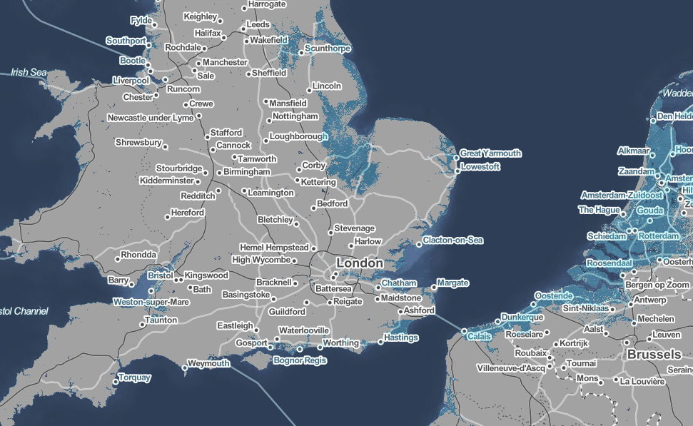
Climate Central’s Benjamin Strauss and Scott Kulp mapped local sea level rise projections worldwide, and calculated that, unless large-scale new protections such as sea walls are built, the homes of 153 million people – more than double the population of UK – could be permanently flooded this century. Though they warned that the ground elevation data they had to use is known to underestimate coastal exposure to sea-level rise and that “the affected population could be substantially larger.”
Climate Central’s Surging Seas (below) is an interactive map based on these newest local sea-level rise projections for 2100, which you can explore to see how your area will be affected based on two scenarios. The first is a failure of the Paris Agreement and continuing unchecked carbon emissions, which scientists call RCP 8.5, leading to 3°C of global warming.
The second scenario shown is “sharp carbon cuts,” which corresponds to RCP 2.6, consistent with 1.5°C warming or less. Under this scenario, annual emissions peak in 2020, decline sharply to reach zero just after 2080, and become slightly negative after that – difficult and expensive to achieve.
Dr. Robert Kopp who led the study has warned it will be decades until we know a more exact picture of how the world map will look by 2100, and it largely depends on how decision makers decide to tackle pollution.
“Consider two roads. One leads to 2 feet of global-average sea-level rise over the course of this century, and swamps land currently home to about 100 million people. The other leads to 6 feet of rise, swamping the homes of more than 150 million,” he wrote in a blog on the study in Climate Impact Lab this week, adding: “our study also shows that the world can make the 2-foot road much more likely by meeting the Paris Agreement goal of bringing net greenhouse gas emissions to zero in the second half of this century.”
RELATED:
https://www.thelondoneconomic.com/news/revealed-the-sinister-lobbying-network-spreading-disinformation-about-climate-change/11/12/
https://www.thelondoneconomic.com/news/environment/heart-wrenching-face-global-warming-polar-bear-starving-death/08/12/
https://www.thelondoneconomic.com/news/environment/single-use-plastic-tax/10/12/
https://www.thelondoneconomic.com/news/struggling-honey-bee-saved-boosting-gut-bacteria/12/12/

