EOS SAT-1 satellite powered by EOS Data Analytics (EOSDA). Image: EOS Data Analytics
On January 3, 2023, the vendor of AI-based satellite imagery EOS Data Analytics stepped closer to independence from data providers by deploying the EOS SAT-1 satellite. It’s one of seven machines that will make the EOS SATconstellation designed for agricultural clients and their adjacent businesses. SpaceX’s Falcon 9 rocket deployed the satellite to low Earth orbit from the Cape Canaveral Space Force Station in Florida.
We chatted with Rim Elijah, VP of Sales at EOS Data Analytics, about the constellation and its customer benefits.
Sure. EOS Data Analytics is a provider of AI-based satellite imagery analytics. The company partners with governmental, commercial, and scientific organizations from across the globe. Our main product is EOSDA Crop Monitoring, an online satellite-based precision agriculture platform for monitoring fields getting updates on the crop and soil state.
In July 2021, we deployed EOSDA Forest Monitoring, online satellite-based software for convenient and sustainable forest management. We also have EOSDA LandViewer for searching, downloading, and analyzing multi-source satellite imagery.
When I joined EOSDA in 2020, I had a general knowledge of agriculture, but I’m a quick learner. On top of understanding the ins and outs of the market, I became experienced in growing plants. Now, if you show me a diseased home flower, I could tell you what’s probably wrong with it and advise on treating it. It’s a professional deformation [smiling].
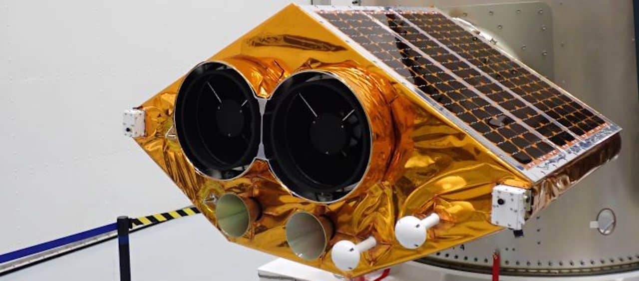
EOS SAT is a satellite constellation designed for monitoring farmlands. It’s the first agri-focused swarm among companies using remote sensing technologies in their products and services.
It consists of seven small satellites following a sun-synchronous orbit, meaning 50% of the time, the satellites fly above the light side of Earth. Thanks to that, their optical cameras can take images clearly showing the features of the planet’s surface.
We aimed to have data that fully meets the needs of our customers in terms of resolution, the number of spectral bands, the frequency of updates, and other parameters. Another goal was to be less dependent on third-party data providers: even if there were problems, we wouldn’t be able to service our customers.
How did we define what data is missing? We collected internal feedback from scientists and developers, requests from customers and prospects, and then researched the satellite imagery market. The team concluded the only way to obtain proper data with needed properties is by manufacturing satellites that can generate it.
We cooperated with the Noosphere group of companies of Dr. Max Polyakov, international space entrepreneur and the founder of EOS Data Analytics.
For example, the Dragonfly Aerospace team designed, manufactured, and tested every detail of EOS SAT-1. Dragonfly also developed software for satellite management and the Mission Control Center for the first machine and the entire swarm. Space Electric Thruster Systems (SETS) has developed the first satellite’s electric propulsion system, creating thrust to maintain the satellite in the set orbit.
The construction of the EOS SAT-1 satellite as part of the agri-focused EOS SAT satellite constellation powered by EOS Data Analytics. Image: EOS Data Analytics
Building a satellite constellation is beneficial because it permits us to:
Top features of the EOS SAT-1 satellite as part of the agri-focused EOS SAT satellite constellation powered by EOS Data Analytics. Image: EOS Data Analytics
In addition, launching EOS SAT will allow us to manage all steps of working with satellite data, from generation, processing, and analysis to presenting analytics results.
Oh, there are many use cases for this data! Let me tell you about some of them.
First and foremost, EOS SAT will enable field monitoring against numerous parameters, such as crop growth tracking and soil moisture measurement. That’s when images shot in various spectral bands come in handy. Spectral bands are regions (ranges) of the light spectrum. And the light spectrum represents all forms of light. Bands visible to us humans are Red, Blue, and Green. Invisible bands allow people ‘seeing the unseen’, for instance, chlorophyll amount, moisture levels in soil and crops, or defects in fruits and vegetables.
EOS SAT-1 will make images using 11 spectral bands tailored for farmland monitoring. The following machines will have 13 bands, including two SWIR (short-wave infrared) ones.
The more spectral bands cameras support, the more various questions about field state one can find answers to via our precision farming platform, EOSDA Crop Monitoring. Moreover, high-quality satellite data influences the accuracy of analytics, among other things.
Customers may not worry about making sense of imagery data. They don’t need to be data analytics experts since the precision agriculture platform EOSDA Monitoring processes data and provides valuable insights. Users need to choose what information they need to get. And high-quality data from EOS SAT will ensure the results are as accurate as possible.
Farmers can also detect problem areas. The high spatial resolution of up to 3 meters and the vegetation index analysis will help farmers precisely detect anomalies in their farmlands. Knowing where to direct one’s attention increases the chances of saving crops.
Overuse of crop care products and fertilizers is another use case. EOS SAT data can be analyzed with vegetation indices to create productivity and vegetation maps to define the optimal input amount for a specific field zone. So, no wasting any inputs on healthy crops.
At the same time, input manufacturers can use satellite images of fields before and after applying newly produced inputs and monitor how each test product affects a specific soil and crop.
Finally, agricultural coops can share updates about their operations and field conditions based on analyzed high-resolution images from EOS SAT.
To sum up, businesses can concentrate on what they do best, and we’ll serve them the information they need to make everyday decisions that will help them succeed in the long run.
Although we focus on the agro-industry, we’re not limited to this. We have been growing as a company and expanding areas of activity since 2020.
The R&D department is actively working on maritime use cases, particularly ocean monitoring, which includes measuring water height and surface temperature, ocean color analysis, and tracking seawater movement and weather monitoring.
Carbon emissions control is also in our focus, with carbon sequestration related to forests and soil as the primary use cases.
We’ve been part of Horizon 2020, which allows our specialists to gain experience in the mining project. [Editor’s note: Horizon 2020 is the European Commission-funded project that entails developing an AI-based platform for mine site monitoring. EOSDA provides satellite data processing within the initiative.]
As you see, all our areas of work are environment-related and align with 10 out of 17 United Nations Sustainable Development Goals, such as life on land and below water, climate action, and responsible consumption and production. EOSDA focuses on leveraging space technologies, notably satellite monitoring, to provide clients with insights they could use to the benefit of Earth.
Let me sum up. Customers from various industries reach out to us with requests, and we can deliver on them. If we’re not fully booked with ongoing projects, of course [smiling].
After launch, the satellite will have a three-month testing period. Users will be able to use data from the satellite starting in April 2023, approximately. So, stay tuned!
