Farmers worldwide are probably concerned with the same question: how to improve crop production while optimizing resource use and reducing environmental footprint. Their concerns stem from economic factors like sky-rocketing fertilizer prices or ecological facets, such as climate change-driven weather extremes that have become more frequent over decades.
Following the principles of sustainable agriculture is the way out. Brijesh Thoppil, Director of Strategic Partnerships at EOS Data Analytics, a global provider of AI-powered satellite imagery analytics, discusses how satellite analytics pushes the sector toward sustainability.
I joined EOS Data Analytics in April 2021. I have over 11 years of experience in various roles, including business development, implementation of technical projects, and management. At EOSDA, I am primarily responsible for the management, growth, and development of the company’s strategic partnerships, both existing and new.
The company, headquartered in California, U.S., engages more than 200 employees. Among them are five professors and 15 Ph.D. holders that lead R&D scientists. EOSDA provides three products — EOS Crop Monitoring, EOS Forest Monitoring, and LandViewer — used by people from 195 countries.
We have more than 22 active partners: government scientific organizations and commercial companies. We serve farmers, input suppliers, IT and insurance companies, banks, consultancies, and more verticals. But our main focus is agriculture.
I wanted to support the company’s sustainability commitment. EOSDA offers innovative solutions to tackle food insecurity and, at the same time, suggests adaptive methods to tackle climate change and environmental degradation issues. As more than 70% of the agricultural output is food-based, the world counts on agriculture to produce more food for the ever-increasing population and improve the livelihood of people involved in the industry.
In simple words, satellite imagery analytics allows you to monitor, control, and manage the state of crops from the comfort of your home. But why do farmers need to use these images, and how?
Part of the issues that farmers face is yield loss. Theproblem can be related to high expenses on fertilizers, pests, diseases, and the lack of time for regularly inspecting the whole territory of the farm. Let’s say you have 10 hectares of land, and you can’t be all over the place.
The lack of knowledge (from data) on the fields’ status and understanding how to interpret data indirectly threatens field productivity. That’s where our technology comes in handy. Smallholder farmers can use vegetation indices to assess crop health or get automated email notifications on vegetation change. So, this information can help one detect issues in the early stages (e.g., pests or weeds) to avoid substantial crop damage.
Fertilizer prices are increasing due to EU sanctions on Belarus imposed in response to Belarus’s support of the Russian invasion of Ukraine. But there is a solution. The EOS Crop Monitoring platform has the zoning feature to make variable rate maps for precise seeding and fertilization in customers’ fields. Variable rate application means applying fertilizers in a needed amount only to the field areas that need nutrition, without wasting any inputs on healthy crops.
Another service I’d like to talk about now is weather data. We provide historical weather data since 2008, daily weather for fields within a 9 square km area, and weather forecasts through the precision agriculture solution. Farmers who rely on these insights can plan irrigation and even protect plants in case of a cold or heat stress.
We also have one feature related to soil, and it’s also based on satellite remote sensing — soil moisture data. It helps users identify the sowing date at the early stages. For example, rapeseed won’t be sown on dry soil; the soil must be of a specific moisture level. Farmers will be able to forecast and monitor periods of droughts by using soil moisture data at the root zone and surface level. Moreover, farmers can prevent their machinery from getting stuck in the mud by knowing whether the soil is excessively moist.
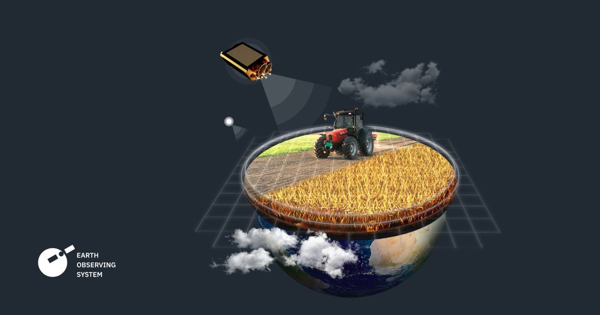
How does EOSDA monitor farms from space? Benefits of satellite data. Image: EOS Data Analytics
Anyone in the satellite imagery analytics business understands there are many satellites providing open-source data and commercial ones generating data that can be used for agricultural needs. However, all that equipment isn’t fully focused on agriculture.
We’re building our own EOS SAT constellation that will consist of seven optical satellites; the first one will be launched into low Earth orbit by the end of 2022, while the last one — in 2025. Through the constellation’s technical capability and scientific expertise of our team at EOSDA, we will be able to generate insights of a higher quality for more precise identification of diseases and pest infestation, monitoring of vegetation state, and soil water balance.
Data from EOS SAT will also ensure better results in cold stress monitoring, crop classification and field boundary detection, and yield modeling. Its usage will also result in more accurate recommendations for fertilization and irrigation, which, in the end, will allow farmers to get an optimal crop rotation plan.
Let me give you an example. If we’re talking about disease detection, farmers will know what chemicals to use to heal their crops. Consequently, insights about crop condition and the opportunity to timely react to spotted issues is very important for yield modeling and prediction. Forecasts on farmers’ agricultural output will also be valuable for banks, insurance, and agricultural lending companies that can decide a loan size and ensure compliance.
They will be able to access these capabilities directly through the EOS Crop Monitoring platform. These days, we obtain open-source and exclusive data from available satellites. But once we launch EOS SAT, we will solely use in-house data. So, what will change for customers is its quality and, in turn, higher accuracy of analytics.
