(
One of Britain’s longest legal disputes – a row over a tiny rural footpath which has rumbled on so long that the original claimants died – has finally been resolved.
Nearly 60 years after a footpath was wrongly included on a local authority map and the family who were besieged with walkers traipsing past their front door objected to it being listed as a public right of way, the saga has finally been wrapped up in their favour.
After long-drawn out High Court battles and inquiries the “muddy track” will be removed form Ordnance Survey maps, 58 years later.
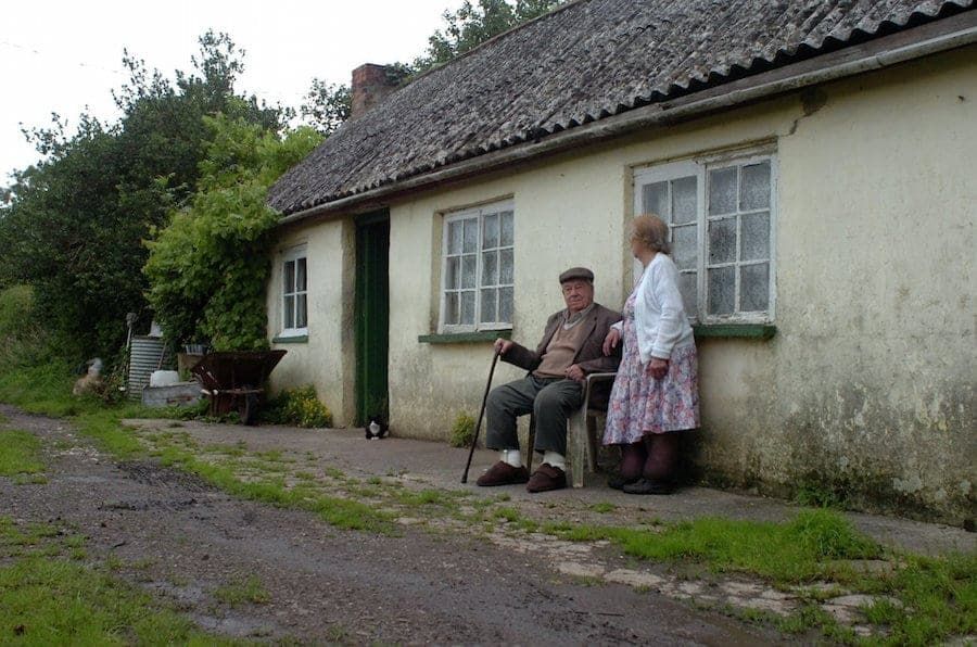
Siblings Archie and Ivy Peppard, who have both since died, began contesting the inclusion of a footpath outside their tiny cottage on a map in 1973.
The cottage was built in 1840 by Archie and Ivy’s great-grandfather, in High Ham, Somerset, where family have lived since the 18th Century.
But in 1959, Somerset County Council wrongly listed the path as a public right of way, and soon the siblings were dealing with ramblers traipsing past their front door on a daily basis.
Eventually their local MP, former barrister Mark Robinson, suggested they get legal representation – and recommended Marlene Masters, now 80, to fight their case.
Working on a pro bono basis since 1994, Mrs Masters has been in and out of the High Court on behalf of Ivy’s son Rodney, 56, and described the case as a “David and Goliath battle.”
Working on a pro bono basis since 1994, Mrs Masters has been in and out of the High Court on behalf of Ivy’s son Rodney, 56, and described the case as a “David and Goliath battle.”
She said: “They were just country folk weren’t educated, and the county council took disproportionate advantage.
“The whole case should have been about whether the objectors had evidence of a right of way.”
Both Archie and Ivy died in 2011 – the year before the row appeared to come to an end, but Rodney, 56, still lives in the cottage.
In 2012, Mrs Masters won a High Court judgement against the council, which led to a new public inquiry.
But when the findings were delivered two years later, ordering the council to delete the footpath from maps, two objections were lodged, one by a rambler and another by the South Somerset Bridleway Association.
It was hoped the dispute could be concluded once and for all after another public inquiry was held in July – and the findings supported Mrs Masters and the Peppards.
Mrs Masters paid an archivist to bring historic documents to the public inquiry, arguing that no right of way would be shown on the 1799 Inclosure Award as the Peppards’ house was not built for another 41 years.
“If the cottage was built in 1840 then how could it show up on a 1799 map?”
She added: “It is so basic that you couldn’t make it up.”
Archie had built a gate to keep walkers out of the smallholding but was taken to county court and told to remove it, his old friend said.
Mrs Masters spent “incalculable hours” helping to fight for the Peppards’ after taking their cause to hard, and received no cash for it.
Planning inspector Alan Beckett ruled in favour of the footpath being removed from the official Somerset County Council maps.
He said the 18th Century documents did “not provide evidence of the reputation of the route as a public right of way.”
And he accepted evidence from the Peppard family that the track was overgrown with plants and had a duck pond in the middle of the route.
But Mrs Masters fears another challenge could be lodged by the South Somerset Bridleway Association, contesting that the track is a bridleway rather than a footpath.
She added: “There is nothing scenic about it, it is a muddy track with a high hedge on one side and woods on the other.
“I am sure anyone aware of this problem would agree that the Peppard family should now have peace and quiet on their own property.”
A spokesman for Somerset County Council said: “The order to delete the public footpath from the Definitive Map and Statement has now been confirmed by the Secretary of State, and we will be publishing formal notice of this in the local press shortly.
“We will be updating our records in the coming days to show that the route is no longer recorded as a Right of Way.
“The Ordnance Survey will also be informed of the change in order that they can update their mapping.”
https://www.thelondoneconomic.com/property/couple-spend-just-1200-year-living-off-grid-hilltop-coastal-fort/04/09/
https://www.thelondoneconomic.com/property/garish-lego-brick-extension-nominated-britains-ugliest-house/04/09/


